Today was another transition day but unfortunately I don’t have anything nearly as profound to say as I did on Monday.
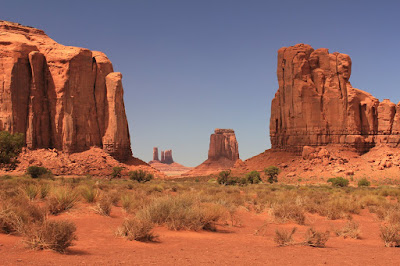
This morning, after learning that the hotel laundry room was finally operational again, I managed to do all my laundry before the 11am checkout time, before hitting the road and getting myself out of Utah Grand Canyon , but of course I had to take the scenic route. This time it was US 191 to US 163 through the Navajo Nation and Monument Valley Monument Valley Monument Valley Monument Valley Monument Valley
See? I knew you’ve heard of it before.
As a Tribal Park , Monument Valley is administered by the Navajo Nation, not the US
One of the most striking aspects of the approach to Monument Valley San Juan river . Since the entire area is comprised mainly of sandstone and shale, the water can’t seem into the surrounding ground to be used for drinking or irrigation. Instead, it has eroded a canyon around itself, depressing the water level far below the surrounding towns. In short, the Navajo people’s commitment to its ancestral homeland is rather impressive.
That commitment made me a little nervous about what I would encounter in Monument Valley
Instead, at the clean, modern, well-equipped visitor center, I found friendly inviting young ladies working behind the counters (clearly a summer job) and a very impressive gift shop, stocked with the best variety of quality reasonably-priced stuff I’ve seen anywhere on this trip (including some great refrigerator magnets and classroom posters). I bought more stuff than in most of my stops so far, which I was glad to do, given the conditions of the surrounding towns and knowing that the proceeds go directly to the Navajo nation, but I didn’t feel like I was giving them more money than normal just to be nice. There was really just that much good stuff there.
So now that I’ve gone on ad nauseam about the gift shop, my next stop – the main attraction of the park as far as I was concerned – was the park loop road. I thought that this scenic drive, which is 17 miles long, unpaved at best, and made up of loose boulders at worst, would cost extra on top of admission to the park, but I was wrong, and just drove out from the visitor center.
It’s strange that, from the outside, the area doesn’t really look like a valley, but once you’re inside the mesa walls towering around you make it clear how the region got its name.
Aside from the extreme eastern part of Utah
Speaking of the car, I feel like I owe it a big thank-you prize for putting up with this road today. It was clearly unhappy with the idea of driving around Colorado Springs
 |
| Dust Devil |
So the car and I made it out of Monument Valley , crossed the border into Arizona
Well, at least for the first 3 miles into the Grand Canyon State
I stayed behind the California
Horseshoe Bend is a 270-degree meander in the Colorado River just outside of Page (as in 3 miles from my hotel), accessible via a quarter mile hike (which was a bit more strenuous than I expected, since there was a hill of sand halfway through the trail). For almost the entire trail, it looks like you’re just walking through sand and gravel towards nothing.
Then, when you finally reach the end, you look straight down and see that the river has carved 1,000-foot sheer cliffs in the surrounding rock.
The only way to get a picture of Horseshoe Bend in its entirety is to teeter right out to the very edge of the cliff and look down. It didn’t help that it was windy tonight, so for me it involved finding a rock just before the cliff that jutted up, so that I could lean against it and have some assurance that I might not plummet to my death (I have no idea how I’m going to handle Taft Point at Yosemite, where there’s a similar situation by the drop is over 5,000 feet). As it turned out, even at its widest setting, my lens wasn’t really able to capture the entirety of the bend. But the thing is so huge you can’t really blame the camera. For perspective, at the bottom near the center, on the inside bank of the river is a small boat. You’re going to have to blow this one up to full size to see what I mean.
The scenery continues to impress as I approach one of the Big 3 destinations (along with Pikes Peak and Yosemite), the Grand Canyon.


If that car picture isn't a candidate for an ad, I don't know what is!
ReplyDelete