Because there’s a $700 surcharge to rent a car in Montana and return it in Canada, I come to you tonight from Calgary.
Let me explain. Originally, this
trip had us flying into Kalispell, renting a car, making our way across
Glacier, crossing into Canada to see Banff, and flying out of Calgary. The
surcharge effectively ended that idea. Fortunately, I managed to pry enough
brain cells away from the Rule Against Perpetuities to come up with a solution:
Do half of Glacier, go to Banff, do the rest of Glacier, and return the car in
the country from whence it came. In my eyes, an eminently reasonable solution.
And one that no one wanted to do. I’m still not entirely sure why the
opposition, but in my delicate pre-bar state, I had no patience for people
being irrational. The only obstacle keeping us from visiting the Canadian parks
was gone, so what was the problem?
In any event, if they wouldn’t do
my solution, I’d split off from the group and do it myself. I figured it was a
good idea anyway, in the event of a repeat of the Yosemite situation, to give
us all a break if needed. It wasn’t really needed, but it did get me the
opportunity to see another of the world’s most scenic landscapes. So here’s how
that went.
Before I could get to my day and
a half in Banff, I had to first manage to rent a car, come down from the
mountains, get car and myself across the Canadian border, and traverse 200
miles of vast empty Alberta steppe. In so doing, I came to the rather
unsurprising revelation that Canadian steppe and American plains look exactly
the same.


After getting stuck in Friday
rush hour traffic (with Canadian drivers who all apparently respond to
indecision while driving by letting their car idly roll for 20 seconds – when enough
of them do it at once, I can actually feel myself getting dumber), I turned
west and took what I thought at the time was a scenic drive back up into the
mountains. Turns out I had no idea how scenic the Canadian Rockies could
become.


I had three goals at Banff –
catch a good sunrise, drive to the top of the Icefields Parkway to see the
crazy things there, and get a frameable picture of Moraine Lake. I managed at
least two of those.
I got my sunrise this morning
after waking up at 5 and driving the 80 minutes from Calgary into the park. Why
stay so far away? I thought it would save me money. What I didn’t realize is
that gas in Canada is at least three times as expensive as it is anywhere in
the US. So that was sort of a wash. But I did get to know the Alberta stretch
of the Trans-Canada Highway very well. Anyway, this morning it was already
threatening to rain but the clouds broke at just the right moment and created
one of those sunrises where you can turn in every direction and find multiple great
views.


Also, as I was driving out, one
of the park’s 65 bears ambled across the parking lot 15 feet in front of me. So
there was that.
I was done there at 7, so I decided to drive
around for a little while before heading up the Parkway. I ended up at Lake
Louise, which I guess is one of the main attractions of the park? I assume so, because
it was more developed and crowded than anything else I’ve seen this week. It’s also
fairly pretentious, boasting a historic hotel with gates and signs reading “hotel
guests only past this point.” National Parks: for the benefit and enjoyment of
the people. The people who can afford to stay in the super swanky chalet. Oh,
and the lake itself wasn’t exactly ugly.


Eventually, I made my way onto
the Icefields Parkway – the main scenic road between Banff and Jasper National
Parks. My first stop was Peyto Lake.

After that point, the road got really scenic. I’ve now driven the Blue
Ridge Parkway, Pacific Coast Highway, Cabot Trail, Kankamagus Highway, and
probably a few more, but after today I can say confidently that none of them
hold a candle to the Icefields Parkway. The road starts with snowcapped peaks
towering over you and the mountains proceed to get taller and closer until you
turn a corner and you’re looking at the largest icefield in North America, and
you’re face to face with a goddamn glacier.


After taking a few minutes to try
to wrap my head around the immensity of the scene in front of me, I started out
for the trail taking me to the toe of said glacier. Even though it was raining
(pouring), and it was 47 degrees, and reaching the glacier required a steep 20
minute climb that started at 6,000 feet of elevation, and climate change has
made it impossible to actually touch the glacier (it’s surrounded by a river
and lake of meltwater now), this was hands down one of the most incredible
things I’d ever seen.

With nary a tree as far as the eye
could see, it almost felt like I had driven to the moon.

There was even a goddamn ice cave.

After driving a bit further north
– far enough to cross into Jasper National Park – I reached my turnaround
point: the relatively underwhelming (considering what it was trying to follow)
Tangle Falls.

From there, I turned back south to
do the entire Parkway in reverse in enough time to catch my Moraine Lake
sunset.
One stop on the way back, though,
is definitely worth mentioning. The Parker Ridge trail, on the border of Banff
and Jasper, is billed as a 1.8 mile hike ascending 750 feet, climbing above the
treeline and ending along a ridgeline that provides 360-degree views of both
parks, and the Saskatchewan Glacier – headwaters of the river of the same name.
This hike was spectacular. It was definitely a workout navigating the half
dozen switchbacks, but the payoff was well worth the effort.
Despite polite Canadian signs
requesting that hikers stay on the trail, at the top of the ridge, the trail
just sort of fades away and I was free to explore the mountains. It was rugged
enough that I couldn’t see over the next hill, but gentle enough that I wasn’t
opposed to walking over that hill. I spent over a half hour at the top trying
to decide which was my favorite view (and trying to take an epic real-camera
selfie).


From there, it was on to Moraine
Lake. Moraine Lake is, for my money, the most iconic landscape in the Canadian
Rockies, and for good reason. Ten mountain peaks, dusted with snow all year
round, are clustered around a turquoise lake ringed with evergreen forests. The
best pictures there come at sunrise, so I gave myself two chances for a good
one. First I drove straight to the lake on my way into the park last night. It
was pretty obvious that there wouldn’t be a sunset, so I just explored the lake
for a while and basked in its grandeur.
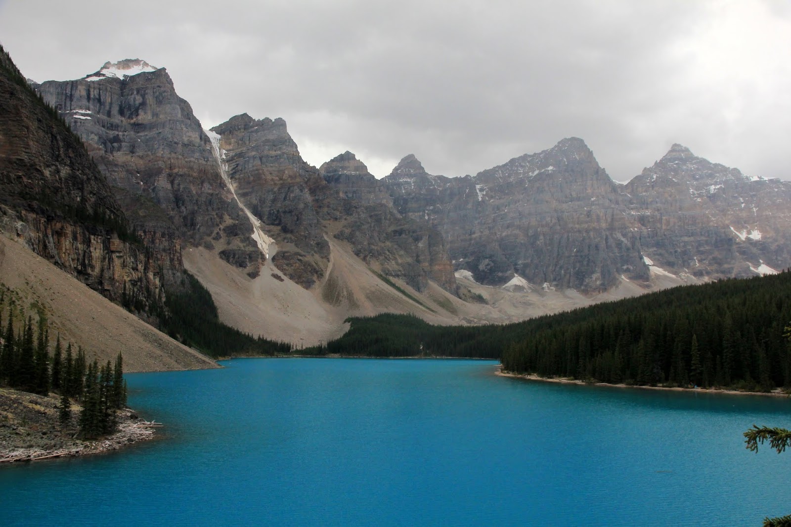

Night two held more promise. As I
drove south, breaks in the clouds started developing and when I got to Moraine,
there was blue sky above me. In the end, the clouds were dramatic, but there
wasn’t much by way of color in the sky.


I guess that means I have a
reason to come back here. Well, one more reason. I could probably spend at
least a week here in a constant state of awe, as each vista tries to outdo the
previous one. And there are three more Rocky Mountain national parks adjacent
to Banff.
Tomorrow, the fellowship reunites
and it’s back to Glacier. But after this, it’ll be a tough act to follow.
No comments:
Post a Comment