Finally.
After a week of delays, my Great Dixie Adventure culminated
with a visit to Virginia’s
Shenandoah National Park, which was once again open
for business. Well, at least the road was open for business. From what I could
tell, I seemed to be the only person who knew about that, because I only saw 7
other people during my day in the park. This helped to provide an added measure
of privacy and seclusion, because those are two things that Shenandoah, through
an unfortunate accident of geography – doesn’t really have going for itself,
most of the time.

Shenandoah doesn’t feel like any other national park I’ve
been to, mostly because you never feel completely off the grid there. In just
about all of the western parks, as well as in Great Smoky Mountains, you can look out to
the horizon and see nothing but what nature put there. You get the sense that
aside from you and the other few visitors around you, there isn’t another human
for tens of miles. In Shenandoah, just about every viewpoint includes a town, a
farm, or some other sign of current human habitation. Nevertheless, Shenandoah
still has the potential to be just as spectacular as some of its grander
colleagues.

My day in Shenandoah involved a trip up most of Skyline Drive and 3
hikes – Blackrock Summit, Dark Hollow Falls,
and Little Stony Man.
On each of these, I spent half the trip reveling in how easy a walk this was,
and I spent the other half cursing how long and steep the trail was and
wondering why I had ever decided to do this. In every case, though, I had the
same reaction as I turned around to leave the trail’s destination – that this
had been a good idea and I was glad I had done it.
The first hike of the day, which I had originally planned to
be my sunset hike back before the Snowtacular, was to the summit of Blackrock Mountain. Aside from having the OAR song
of the same name stuck in my head all morning, this one was pretty easy. Part
of the route uses the Appalachian Trail, which
I hadn’t been on for probably close to a decade, and which has a very different
connotation than it did back then (thank you South
Carolina Governor Mark Sanford).
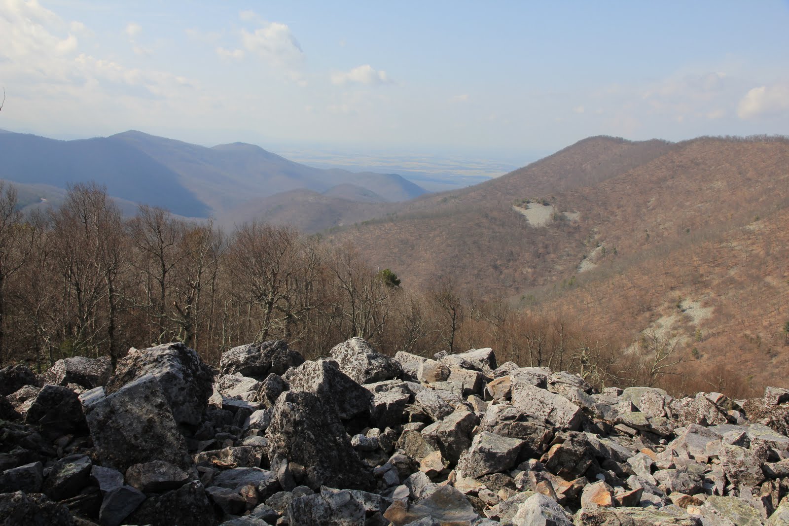
The summit is literally a huge pile of rocks. I’m not quite sure how a talus
slope ends up on the top of a mountain, but there it was.

The trail looped around it, but that wasn’t giving me the
promised 360-degree views I had come for, so I decided to do some
talus-scrambling. I just wish the sign at the trailhead hadn’t mentioned that
rattlesnakes live in the crevices between the rocks, because that just made
each step incrementally more stressful, even though I know that snakes are
cold-blooded and would therefore have no interest in me on a 40-degree morning.
But I braved the reptilian threat and got my 360-degree views.


Of course, the benefit of climbing a mountain is that the
return trip is a piece of cake. In fact, in less than an hour I felt ready for
my next challenge: Dark
Hollow Falls.
Unfortunately, that trail was 30 miles from Blackrock and
the speed limit on Skyline Drive
is 35, so I wasn’t going to be there in an hour. It was just as well, because
weather decided to interlope (for a change). At one of the western-looking
viewpoints, I noticed that the visibility was getting poorer and poorer and it didn’t
seem like that was being caused by pollution. Once the 50-mile-long mountain 10
miles away in the valley began to disappear, I realized it was about to rain.


Fortunately, the MyRadar app (told you I wasn’t off the
grid) confirmed that this should just be a line of thunderstorms that would
pass quickly. They did, but they left behind a thick blanket of that famous
Shenandoah fog.


But I knew this was definitely a good thing, When fog clears
you get patches of low clouds that make for very interesting pictures, and
sometimes you even get rainbows. So I was going to be ready when either of
those things happened. For the better part of 2 hours, I danced with the storm,
moving between easterly and westerly overlooks as the rain and fog waxed and
waned alternately. At one point, when it looked as if I had about 5 minutes
before the skies would clear, I decided to make a quick stop at the nearest
closed visitor center to use the bathroom while I had time. I was so wrapped up
in the thunderstorm tango that as I pulled into a parking spot, I nearly ran
over the deer that was standing in it. But it wasn’t just that one deer, there
were 11 others feasting on the grass in the traffic islands around the
building. Since they hadn’t been put off by my near-miss, I decided that if I
could get out of the car, close the door, walk to the bathroom, return to the
car, and get my camera, all without them running away, they were telling me it
was OK to get as close as I could to take some deery pictures.


I was able to walk among them for almost 20 minutes, getting
within 10 feet of them a few times. It was long enough to see that some of the
adults had no patience for one particular fawn, as they kept whacking him with
their heads when he got too close.


By the time I had gotten all I could out of the deer, the
rain had stopped and the clouds and fog were in a state of equilibrium, so I
gave up the dance and headed to my next destination. I didn’t remember why I
put Dark Hollow Falls
on my itinerary, but I knew I must have had a good reason. Turns out, it’s 70
feet high and it’s the closest of any waterfall in the park to the road. What I
neglected to write down was that it was a 440-foot descent to the falls, which
meant a 440-foot climb back up to the parking lot. So I made sure to enjoy the
walk down as much as possible, because I knew the walk back wouldn’t be so much
fun.
This was a tricky waterfall to get a good picture of. It’s
continually carving out the rocks below it, which moves the water deeper and deeper
into a channel within the rock. So if you’re not standing directly in front of
it, part of the fall is obscured by the rocks. Unfortunately there’s water
right in front of it, as is so often the case with a waterfall. I wasn’t about
to risk slipping and falling into the stream so I had to settle for these:


As I had predicted, the hike back up was arduous. Sometimes
you can’t tell you’re going down until it’s time to start climbing back up. At
least it didn’t start raining until I was at the car, though. However, I was so
tired at this point that I thought I might just skip the last hike – Little
Stony Man Mountain. So I took my time driving up to the trailhead. When I got
there, I was too lazy to get out of the car to read the sign, so I took a
picture of it, zoomed in, and read it that way. the sign-picture called the
hike “easy,” claimed it let to a “spectacular view,” and that it was “a fine
spot to watch a sunset.” At only a half mile, and because it was already 4:30
and I didn’t anticipate finding a better sunset spot, I decided to go for broke
and do it.
As I started out, I realized I didn’t remember ever climbing
2 mountains in a single day. I quickly realized why: mountains are tall and
require climbing to get to the top of them. The advertised half mile trail
involved a series of switchbacks (why do switchbacks always have to come in
series? I’d much prefer some rogue switchbacks), and some climbing up over
boulders. But when I reached the summit and looked out, I knew immediately that
it had been more than worth it:


What the pictures don’t capture is that just beyond those
rocks is a sheer cliff – one where I was never able to find the bottom. The
wind was also ferocious. Despite being 50 degrees, my fingers were soon numb
and on one occasion I was sure my adventure hat had blown off and was now sailing
towards Luray. Luckily it was stuck against one of the rocks.
Little Stony Man boasts 180-degree views with rows of
mountain ridges on either end, and the Shenandoah Valley and distant Alleghany Mountains in between. But what makes
this spot truly unique are the rock formations on the tops of the cliffs.
Jutting up and out randomly, one even sheltered a small pool, which I’m pretty
sure is permanent, since ever picture I’ve ever seen of it has water in the
pool. Actually, though, shelter is the wrong word, because every time the wind
kicked up, it picked up some of the water and hurled it at me, regardless of
where I was standing.

A few minutes after my arrival, the sunset show began.
Between the moment-by-moment changes in colors and lighting, the random gusts
of gale-force winds, and the three distinct types of vistas from this site
(plus the rocks), I had more than enough to keep me busy for the next half
hour.


In many ways, each of these hikes was a microcosm of my
entire 2,500 mile trip. I started out excited, thinking that I knew what was in
store and that things would go according to my plans. Then I was hit with a
cold bucket of reality and had to adjust the plan, if not my expectations,
accordingly. In the end, though, I got what I had come for and was glad I had
done it. Sure, there was the occasional
bump along the way – be it an unexpected 440-foot climb back up from a
waterfall or an unexpected 8-inch snowstorm – but these didn’t actually prevent
me from accomplishing everything on my itinerary.
In the end, I couldn’t have asked for a more perfect ending
to this tumultuous adventure than standing at the edge of a hundred-foot cliff
at the end of a day of turbulent weather, seeing the sun finally emerge from
the day’s final band of clouds just minutes before sunset, and then watching it
light up the Shenandoah Valley and all the mountains within a hundred miles,
before finally dipping below the horizon. Once it was over, all that was left
was to turn off the camera, walk down the mountain, and drive home. So if what
they say at camp is true, and all we really remember from an experience are its
last fleeting moments, I’ll have nothing buy perfect memories from this
week.
Until next time.

Those 3 deer pictures had me giggling. Too perfect.
ReplyDelete